Météo France & TF1 : What the Current Heatwave Means for France
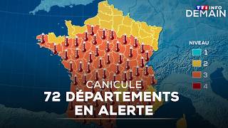
France is in the grip of a strong summer heatwave, and the joint monitoring of Météo France and TF1 has placed ten departments under an orange warning. This article explains the situation, the forecast for the coming days, practical safety tips, and how you can stay updated through the trusted Météo TF1 bulletins.
Why an Orange Warning Was Issued
The orange alert is the second‑highest level in the French heat‑wave warning system. It is triggered when:
- Maximum daytime temperatures are expected to exceed the seasonal average by more than 10 °C.
- Night‑time lows remain above 20 °C, limiting the body’s ability to recover.
- Heat‑related health risks, especially for the elderly, children and people with chronic illnesses, become significant.
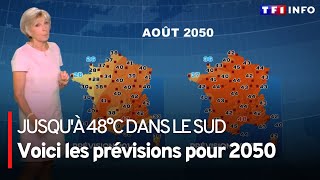
On Wednesday, Météo France confirmed that ten departments – from the Rhône‑Alpes region to the coastal areas of the Atlantic – met these criteria. The bulletin, produced by the Météo TF1 team, highlighted that temperatures are “well above” normal values, with some locations already reaching 38 °C (100 °F) during the afternoon.
Current Weather Snapshot
Across the affected departments the sky is mostly clear, allowing solar radiation to heat the ground efficiently. Humidity is moderate, which makes the heat feel even more intense. The combination of strong sunshine and low wind speeds creates a classic “heat‑island” effect in urban zones, raising temperatures by up to 2 °C compared with surrounding rural areas.
Short‑Term Forecast: Cooling From the North
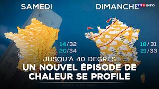
Good news arrives from the north. Météo France’s model ensembles indicate that a cooler air mass will begin to move southward on Sunday. This will bring:
- Lower daytime highs, dropping by 3‑5 °C in the northern departments.
- A more noticeable night‑time cooling, with lows falling into the mid‑teens.
- A gradual, near‑universal temperature decline by mid‑week, as the cooler front spreads across the country.
While the relief will be welcome, the transition period may still feature brief spikes of heat, especially in the interior valleys where cold air can be trapped.
Social Media Buzz: “Polar Winter” Rumors
After the recent heatwave, some users on Twitter and Instagram have joked about an imminent “polar winter.” Although the comment is meant humorously, it is important to clarify that:
- Short‑term weather swings are normal; a sudden cold snap does not equate to a long‑term climatic shift.
- Scientific forecasts from Météo France do not support a rapid transition to winter‑like conditions within the next few weeks.
- Extreme temperature swings are more likely to be localized rather than nationwide.
Sticking to official sources such as Météo TF1 helps cut through speculation and provides reliable information for daily planning.
What to Expect During the Hottest Days
Even with the upcoming cooling trend, the next few days will still feel very hot. The forecast highlights:
- Daytime temperatures climbing to 36‑40 °C in the most affected zones.
- Strong UV index levels (9‑10), increasing the risk of sunburn.
- Limited evening relief, with night‑time lows staying above 22 °C in many areas.
These conditions call for proactive measures to protect health and comfort.
Practical Heat‑Wave Precautions
Both Météo France and TF1 recommend the following steps:
- Hydration: Drink water regularly, even if you do not feel thirsty. Avoid alcohol and excessive caffeine.
- Shade and ventilation: Stay in air‑conditioned rooms or use fans. If you must be outdoors, seek shade and wear a wide‑brimmed hat.
- Clothing: Light, breathable fabrics such as cotton or linen help the body dissipate heat.
- Check on vulnerable people: Elderly relatives, young children, and pets need extra attention.
- Limit strenuous activity: Schedule outdoor work or exercise for early morning or late evening when temperatures are lower.
How Météo TF1 Keeps You Informed
The partnership between Météo France and the TF1 television network produces daily weather bulletins that are widely followed across the country. Key features of the Météo TF1 service include:
- Real‑time alerts: Push notifications on the TF1 app warn of sudden changes, such as thunderstorms or heat spikes.
- Regional breakdowns: Detailed forecasts for each department, allowing residents to see precise temperature expectations.
- Expert commentary: Meteorologists explain the reasoning behind warnings, helping viewers understand risk levels.
- Historical context: Segments like “8 ans plus tard, avec…” compare current conditions with past years, illustrating trends without overstating climate change conclusions.
The latest bulletin, titled “Ce bulletin météo a été réalisé par les experts de Météo TF1,” emphasizes the orange warning and the expected cooling front, reinforcing the need for vigilance.
Staying Updated After the Heatwave
Even after the orange alert is lifted, it is wise to keep an eye on the forecast. The transition to cooler weather can bring its own challenges, such as sudden rain showers or fog in the early morning. Météo TF1’s website and social media channels provide:
- Hourly temperature updates.
- Rain probability maps.
- Air‑quality indexes, which can improve as temperatures fall.
Subscribing to the TF1 weather newsletter ensures you receive the most recent information directly in your inbox.
Conclusion
The current heatwave, marked by an orange warning for ten French departments, underscores the importance of reliable weather information. While temperatures will begin to ease from the north on Sunday and a broader cooling trend is expected by mid‑week, the next few days remain dangerously hot. By following the practical advice from Météo France and staying tuned to Météo TF1’s bulletins, residents can protect their health, plan their activities wisely, and avoid the pitfalls of misinformation circulating on social media.
Remember: staying informed is the first line of defense against extreme weather. Keep an eye on Météo TF1, hydrate, and look out for those who may need extra help during the lingering heat.